
Nyack History A to Z explores the village’s past one letter at a time.
This week, national attention focused on the underground tunnels beneath the Arch Bridge at Memorial Park. After entering the buried course of Nyack Brook, dozens of schoolchildren unexpectedly emerged nearly a half mile away near the Hudson River waterfront. The incident ended safely, but it highlighted the dangers of the village’s stormwater culverts, which are not intended for exploration.
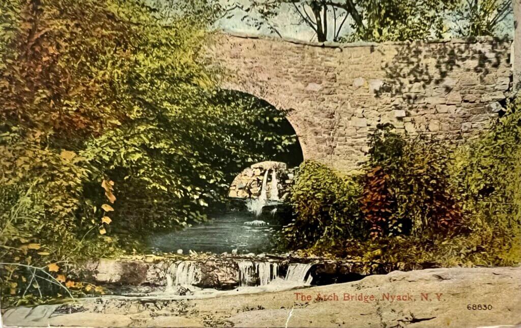
Within the heart of Nyack lies a fascinating piece of engineering, the Arch Bridge. Built of local red sandstone and lined with brick, it stands quietly at the southwest corner of Memorial Park, unnoticed by many who cross it daily. Drivers, walkers, and bikers passing along Piermont Avenue near Hudson Avenue’s T-junction rarely realize they are traversing not only a historic bridge but also a buried piece of Nyack’s past: the hidden Nyack Brook and the remnants of an old mill pond.

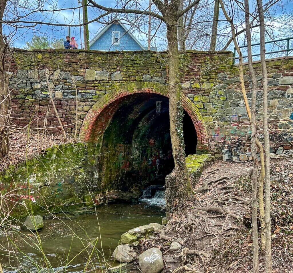
Its scale is easy to underestimate until compared with the people standing atop the span. Photo by the author.
The Winding Path of Nyack Brook
Nyack Brook, once called Mill Brook, was once the village’s geographic “Main Street.” It begins in the clove between South Mountain and Garabrant’s Hill near Oak Hill Cemetery. From there, it tumbles down toward Main Street, flows south between Broadway and Franklin, and turns east toward the Hudson, passing beneath the Arch Bridge. Its flow changes with the seasons, a trickle in dry weather, a torrent during storms.


The stream’s course is shown as it flows from the uplands toward the Hudson River, following the route that would later be largely buried beneath the village streets. From the 1876 map of Nyack
Indigenous communities valued its spring-fed waters and fished near its mouth. Early European settlers saw its power as a resource. Nyack’s first settlers, the Tallmans, built a sawmill and dam near Main and Mill Streets and a gristmill near what would become the Arch Bridge.
As Nyack grew, the brook suffered. Builders gradually covered it, following an “out of sight, out of mind” attitude. Engineers later altered its sharp bend at Main and Bridge Streets — starting as early as 1903 — to control flooding. Today, the brook runs mostly underground, surfacing in only a few hidden spots around the village.
The Mill at Arch Bridge

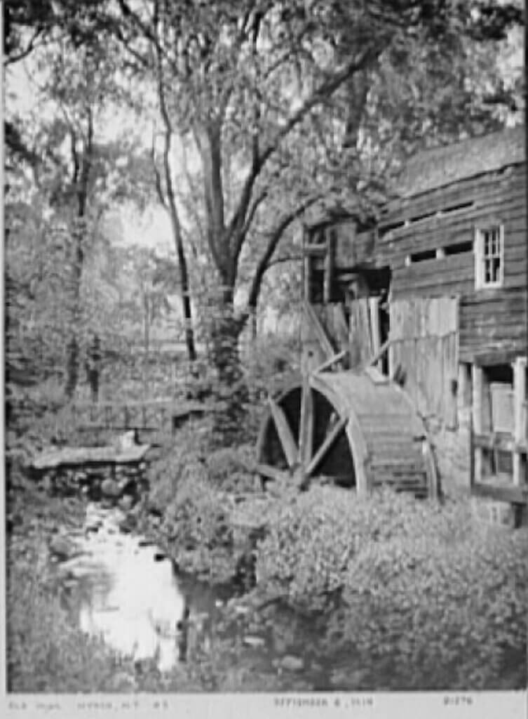
The photograph is out of focus but captures the structure’s advanced state of decay. Courtesy of the Library of Congress.
The Arch Bridge spans a 20-foot-deep gulley along Piermont Avenue, replacing a wooden bridge that served for over a century. Its location once connected two sections of the Depew family farm divided by the brook, and it became a key wagon route to Piermont.

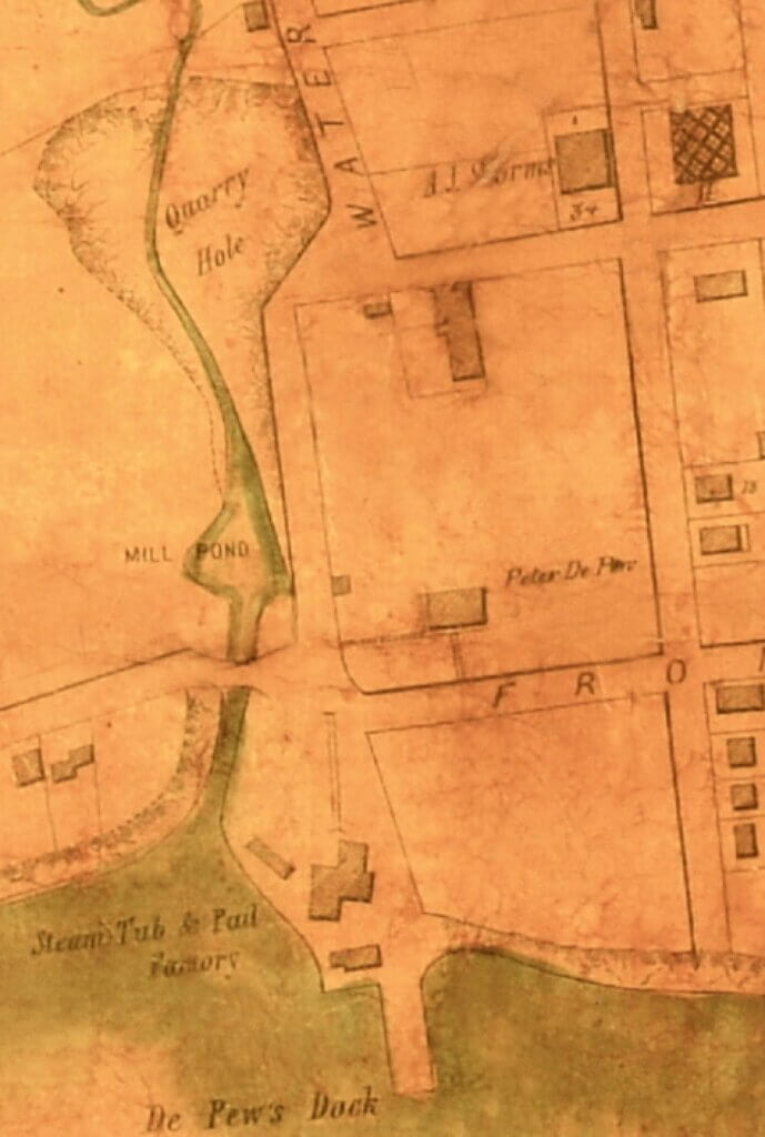
Depew’s bridge spans Nyack Brook at center, with the mill pond, the Storm Brothers Tub & Pail Factory, the nearby quarry hole, and the Depew dock all visible. Courtesy of the Historical Society of the Nyacks.
The area bustled with activity. A gristmill, factories, and nearby docks created an industrial hub. In the early 1800s, a sulfur match factory in the mill employed several children. By 1850, the Storm brothers replaced waterpower with steam in their woodenware factory. That mill later burned, giving way to Grant’s Flock Mill, which produced recycled wool known as “shoddy.”
When Memorial Park was created in the 1920s, the old factory disappeared — its site buried under lawns and trees.

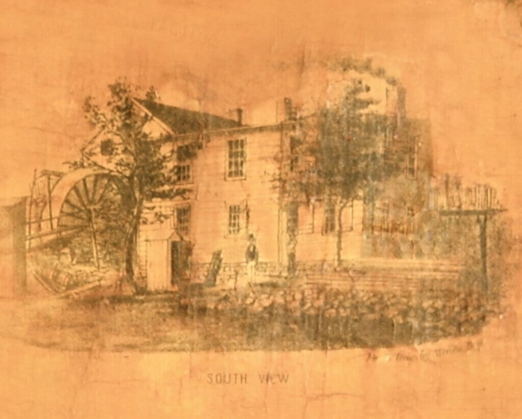
This 1854 illustration shows the mill wheel that powered the operation. Courtesy of the Historical Society of the Nyacks.
The Underground Railroad
This quiet corner of Nyack also holds a powerful legacy. Just south of the bridge lived Cynthia Hesdra, a free Black woman who helped operate the Underground Railroad. Escaped enslaved people are believed to have found shelter near the bridge, using it as a discreet waypoint on their journey north to freedom. Beyond its significance in commerce and industry, this location holds historical importance tied to the Underground Railroad.

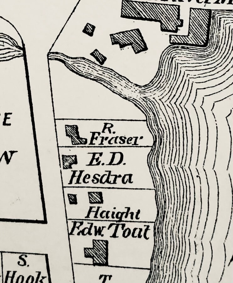
The property lies on Piermont Avenue near where Nyack Brook enters the Hudson River. Memorial Park now occupies the land just above the river shown here. Notably, deeds of the period were recorded in the name of the male head of household; thus E.D. (Edward) Hesdra appears on the map, even though Cynthia Hesdra was the family’s primary earner.
Beyond its industrial importance, the Arch Bridge area formed part of a hidden landscape of movement and refuge. The brook, ravines, and riverside paths offered concealment in an era when freedom seekers often traveled quietly at night.
Floods and Depew’s Glen

This deep ravine reveals the dramatic cut in the landscape created by brownstone quarrying and the flow of Nyack Brook, terrain that would later be partially filled and reshaped. Photograph by Isaac Van Wagner. Courtesy of the Library of Congress.
Every decade or so, Nyack Brook still reminds the village of its strength. In 1845, flooding destroyed both the Depew Bridge and the nearby South Nyack bridge.
The landscape around the brook changed dramatically during the nineteenth century. In the 1830s, the Depew family quarried brownstone east of the mill pond, creating a deep ravine known as Depew’s Glen. The excavation permanently altered the natural contours of the area.
The glen remained an obstacle until 1873, when Orangetown finally bridged Broadway near the quarry. Construction on the Arch Bridge began around the same time.
Later generations filled much of the ravine and buried the old mill pond beneath new development. Today, most of Nyack Brook runs underground through this area, surfacing only briefly in a few hidden locations, including behind Strawberry Place restaurant.
Building the Arch Bridge

Seen from Memorial Park, the view looks through the bridge to the west, exposing the same deep cut of Nyack Brook before later fill obscured the landscape. From the author’s collection.
Rockland County funded construction of the new stone bridge in its 1871 budget. The Town of Orangetown completed the project in 1874, although final costs exceeded early estimates.
More than 150 years later, the bridge remains in service. After heavy rains, water still surges through the tunnel beneath Memorial Park, following the same buried course of Nyack Brook.
Largely hidden from view, the Arch Bridge continues to link modern Nyack with the village’s industrial and environmental past.
The Brook Beneath the Village

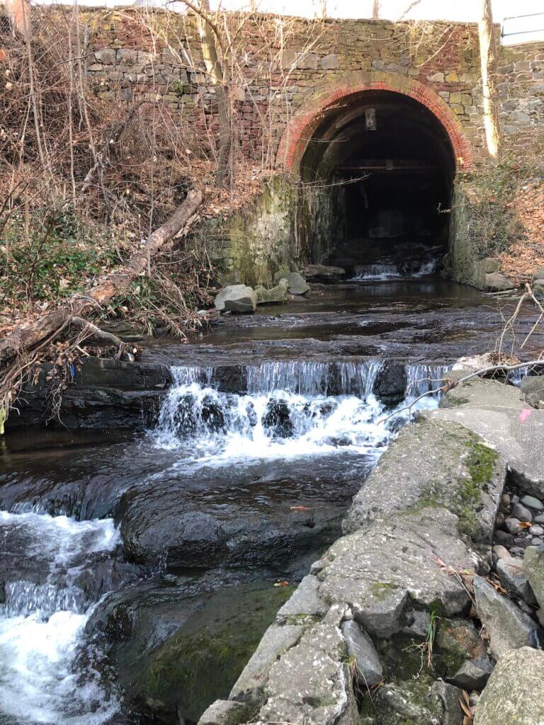
Water still courses through the 1874 stone tunnel at Memorial Park, revealing the buried stream that once powered Nyack’s mills and shaped its early industry.
The recent tunnel incident underscored the dangers posed by Nyack’s old stormwater culverts. Entering near the Arch Bridge at Memorial Park, the students followed the underground brook through dark passages beneath the village before emerging on their own near the Hudson River waterfront. During heavy rains, water can surge rapidly through the confined tunnels with tremendous force. Village officials emphasized that the underground drainage system is not intended for public access or exploration.
Yet the episode also revealed something easily forgotten: beneath modern Nyack, the old brook still flows through the same hidden corridor that once powered mills, shaped the landscape, and quietly carried generations of village history beneath the streets above.
Next: “B” is for Burd Street
About the author
Mike Hays has lived in the Nyacks for 38 years. After a career as an executive at McGraw-Hill Education in New York City, he now focuses on researching, writing, and interpreting local history.
He serves as Treasurer and past President of the Historical Society of the Nyacks. He is also a Trustee of the Edward Hopper House Museum & Study Center and Historian for the Village of Upper Nyack. In these roles, he works with community partners to preserve historic resources and expand public understanding of the area’s past.
Since 2017, he has written the popular Nyack People & Places column for Nyack News & Views. The series chronicles the history, architecture, and personalities of the lower Hudson Valley.
Hays has also developed museum exhibitions, written interpretive materials, and led well-attended walking tours that bring Nyack’s history to life.
He is married to Bernie Richey. He enjoys cycling, history walks, and winters in Florida. You can follow him on Instagram at @UpperNyackMike.