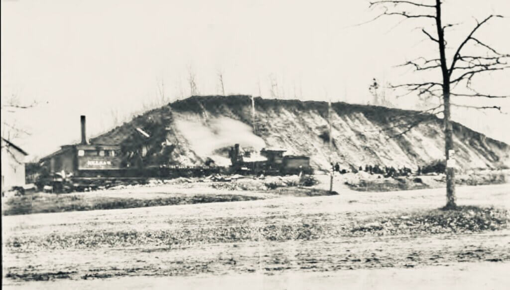
The steep, flat-topped hill rose beside the railroad tracks just east of today’s Depot Square. Within a few years, it would disappear entirely. Courtesy of the Historical Society of Rockland County.
A landform once stood in downtown Sparkill. Not a distant ridge or Hudson River bluff, but a steep, flat-topped rise beside the railroad tracks.
It had a name: Sugar Loaf, and within a few decades it vanished from the landscape.
When an 1887 photograph resurfaced in a Flashback Friday post by the Historical Society of Rockland County, it raised more questions than it answered. Where exactly was this hill? How large was it? And how does a prominent rise simply disappear?
With the help of two local geology detectives, Tom Perry and Karl Mattsen, the search for answers begins. The answer is not only true. It is almost unbelievable.
A Hill Where None Exists
The historical record insists Sugar Loaf was real.
Newspaper notices from the late 1860s describe picnics held atop the hill, praising its shade and easy access. A grove of large trees covered the summit. Visitors gathered there for music and all-day outings. The location placed it just east of the future train station.
But that only deepens the mystery. Stand in Sparkill’s Depot Square today and no such hill appears. The land lies mostly flat. Streets, shops, and parking lots fill the space. Nothing suggests a fifty-foot rise ever stood here.
Yet one question remains: where did it go?
Following the Clues
Perry and Mattsen began with the maps.
An 1876 atlas shows a curious gap near the train station—an open, undeveloped space surrounded by early lots. In a growing hamlet, the absence stands out. Why leave such a large parcel untouched?
Then came the photograph. The 1887 image shows a bare, prominent hill rising beside the tracks. Trees had already been stripped from its summit. The shape is unmistakable: steep sides, a flattened top, and a commanding presence over the surrounding land.
That image fixes two things at once. The hill existed. And by the late 1880s, it was already under assault.
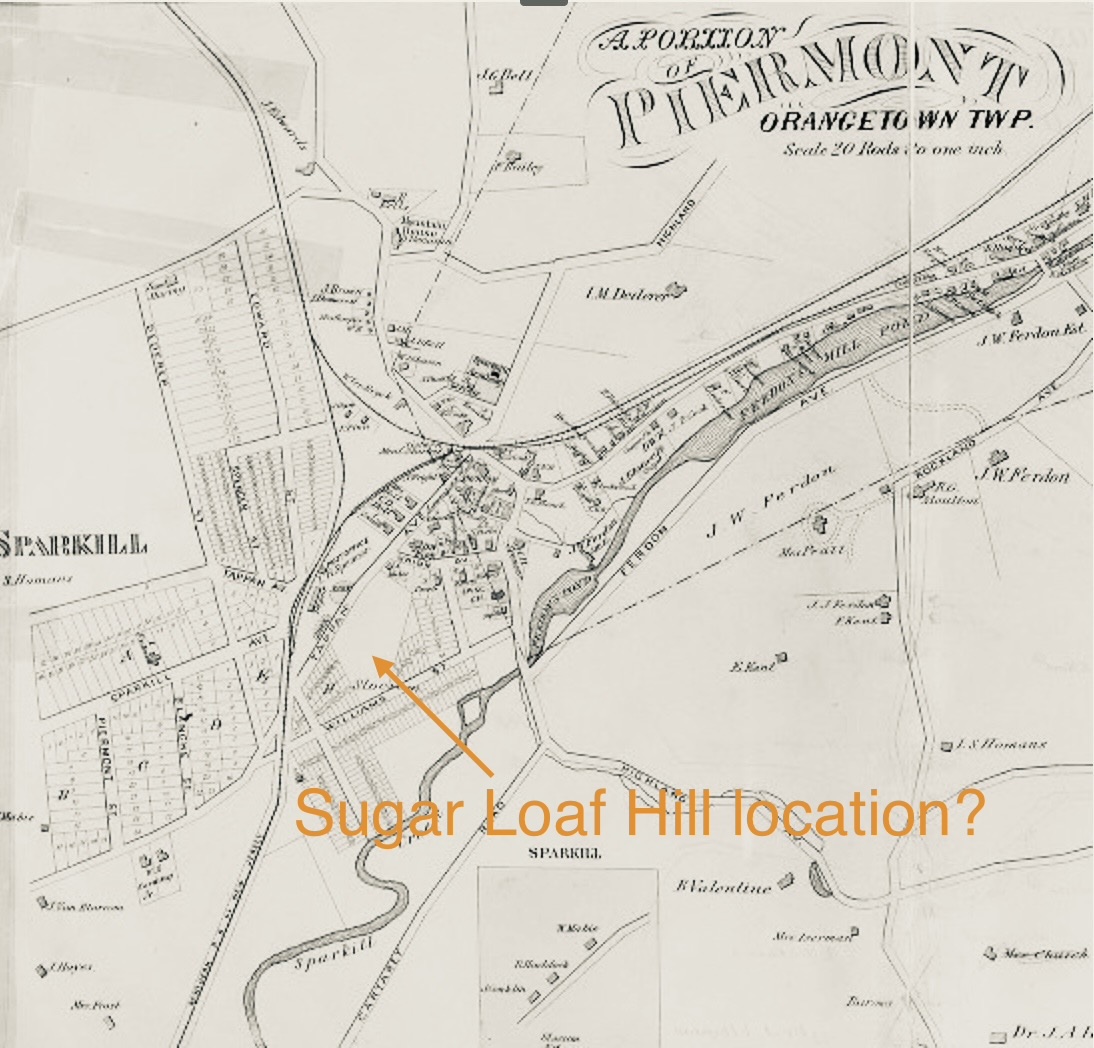
The open space near the train station likely marks the location of Sugar Loaf Hill before development filled the block.
Sparkill Before the Mystery Was Solved
Today, Sparkill feels like a quiet hamlet. The Route 9W overpass keeps through traffic away from its center, and Depot Square no longer echoes with trains.
In the 19th century, however, Sparkill was much busier. The area carried several names before it became Sparkill. Around the Civil War, it was known as Blanche’s Crossing, part of the newly named village of Piermont. The broader area was called the Tappan Slote, or simply the Slote, from the Dutch word sloot, meaning trench or ditch. Later, people identified the hamlet as Upper Piermont.
The Sparkill valley cuts through the Palisades, creating a natural passage between the Hudson River and the interior. Shallow draft sloops once moved up Sparkill Creek, carrying goods and passengers toward Tappan and surrounding farms.
Then came the railroads. In 1871, a new station on the Northern Railroad received the name Sparkill. Older names such as Upper Piermont faded. By the turn of the 20th century, automobiles replaced trains, and Sparkill settled into a quieter identity.
But for several decades, railroads shaped almost everything here, including the fate of Sugar Loaf Hill.
Railroads Come to Sparkill
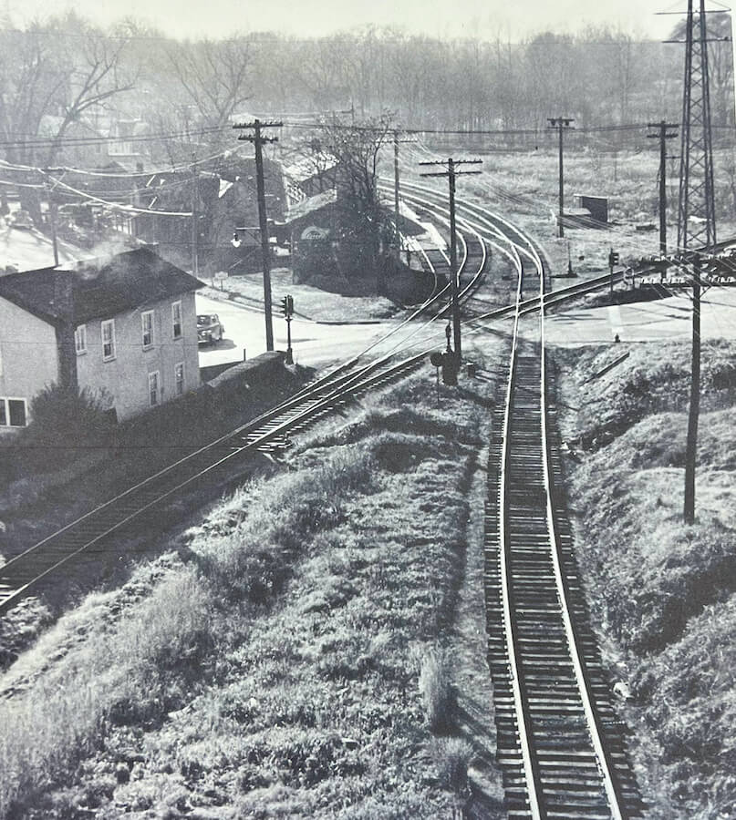
The Erie and Northern Railroad lines crossed in Sparkill, turning the hamlet into a busy transportation junction. The baggage terminal in the center later became a commercial florist. Courtesy of Arbor Hill Garden.
To understand why Sugar Loaf disappeared, we must understand the railroads.
The Erie Railroad put Sparkill and Piermont on the map. Eleazar Lord promoted the line as a faster route from New York City to Lake Erie than the Erie Canal. Because early agreements did not allow trains to pass through New Jersey, Piermont became the eastern starting point.
Work began around 1835. By 1841, trains ran from Piermont to Goshen. On May 14, 1851, the full Erie Railroad opened end to end, with President Millard Fillmore aboard the inaugural trip.
Freight poured through Piermont. Newspapers reported livestock, produce, and manufactured goods moving in both directions. One shipper sent thirty-three tons of eggs in three rail cars. At one point, some 5,000 cars reportedly waited in Piermont for clearance to New York City.
By 1859, more than 200 people worked in the rail yards loading and unloading barges, sloops, schooners, and freight cars. The sound of whistles, locomotives, and labor filled the riverfront.
Then the network expanded. The Northern Railroad connected Sparkill with Jersey City in 1859. A spur to Nyack opened in 1870. Soon two rail lines crossed in Sparkill, turning the hamlet into an important railroad junction..
Excavating Sugar Loaf
The railroad needed enormous quantities of fill to rebuild and expand Piermont Pier, and Sugar Loaf provided a nearby source.
The 1887 photograph of Sugar Loaf under excavation suggests how the operation worked. The railroad did not haul this material by wagon to a distant yard. Instead, crews appear to have brought rail access directly to the hill. A work spur ran along the base, close enough for a locomotive and cars to stand beside the cut face. Sand, gravel, and small rock could be loosened from the slope, moved a short distance, loaded onto cars, and shipped out.
That detail matters. Sugar Loaf was not a small mound scraped away in a weekend. If the hill stood roughly fifty feet high, stretched more than 150 feet, and ran perhaps fifty feet deep, it held an enormous volume of material. Removing it required a planned operation involving labor crews, steam power, excavation equipment, and rail transport positioned as close as possible to the work.
Sugar Loaf likely took its name from the cone-shaped loaves in which sugar was once sold. Before granulated sugar became common, merchants molded sugar into steep-sided forms known as sugar loaves. Hills and mountains with similar profiles often borrowed the name. Sparkill’s hill was broader and flatter than most, yet the name clearly stuck.
How the Hill Disappeared
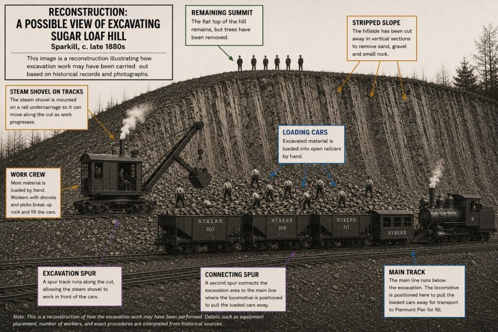
This interpretive reconstruction illustrates how excavation at Sugar Loaf Hill may have operated in the late 1880s based on the surviving photograph, rail practices of the period, and the scale of material removed. Annotations highlight the rail spur, steam shovel, loading cars, and locomotive used to move sand, gravel, and small rock from the cut face toward Piermont Pier. The steep, striated slope reflects the systematic removal of the hill, while the remaining summit suggests what was left before final excavation.
The summit remains visible, but the slope below has been carved into steep, raw faces. Long vertical marks run down the hill where material has been cut or dragged away. At the base, the locomotive and cars sit in the work zone, while nearby figures likely mark the crew. Together, the surviving image and reconstruction show the hill in the process of being dismantled.
Piermont Pier and the Need for Fill
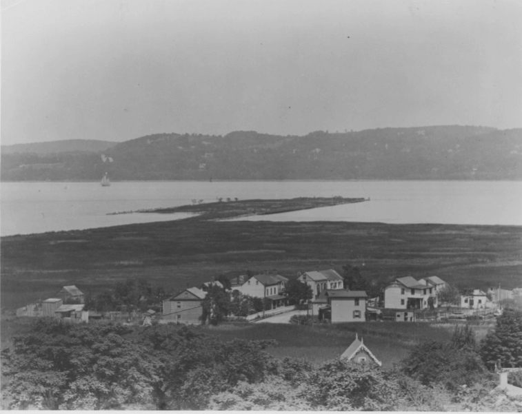
The Hudson River off Piermont is shallow. To connect steamboat freight with the Erie Railroad, workers built Piermont Pier nearly 4,000 feet into the river.
Crews leveled shoreline hills for fill. They drove wooden piles into the riverbed, then reinforced the pier with stone and earth. They also filled much of the surrounding marsh.
By the 1890s, the railroad refurbished the pier for coal transport. That work required large volumes of sand, gravel, and stone. Sugar Loaf stood nearby, made of exactly the material the railroad needed.
In 1872, crews stripped the hill of trees. For a time, the bald summit remained visible beside the tracks. Then, in 1889, the Erie Railroad began removing the hill in earnest. Workers cut into its sides, loaded the material onto railcars from the spur, and sent it toward Piermont. There, the sand and gravel helped rebuild the pier and surrounding land.
Within about a year, the hill had been systematically dismantled for fill.
Reconstructing the Landscape
But where exactly did Sugar Loaf stand?
Here, the clues shift from maps and photographs to the landscape itself.
When Perry and Mattsen walked the site, they found what the maps only hinted at. The ground still preserves subtle evidence of the vanished hill. It rises gently across the old bank property near Depot Square, then falls away.
Along Paulding Place, scattered boulders sit out of place. These rocks differ from the surrounding soil. They appear to be glacial erratics, stones carried and dropped by ice thousands of years ago.
Taken together, the evidence points to a single location: the block bounded roughly by Main Street, William Street, and Union Street, just east of the old station.
The hill once stood there, rising about fifty feet, with a flat top extending more than 150 feet.
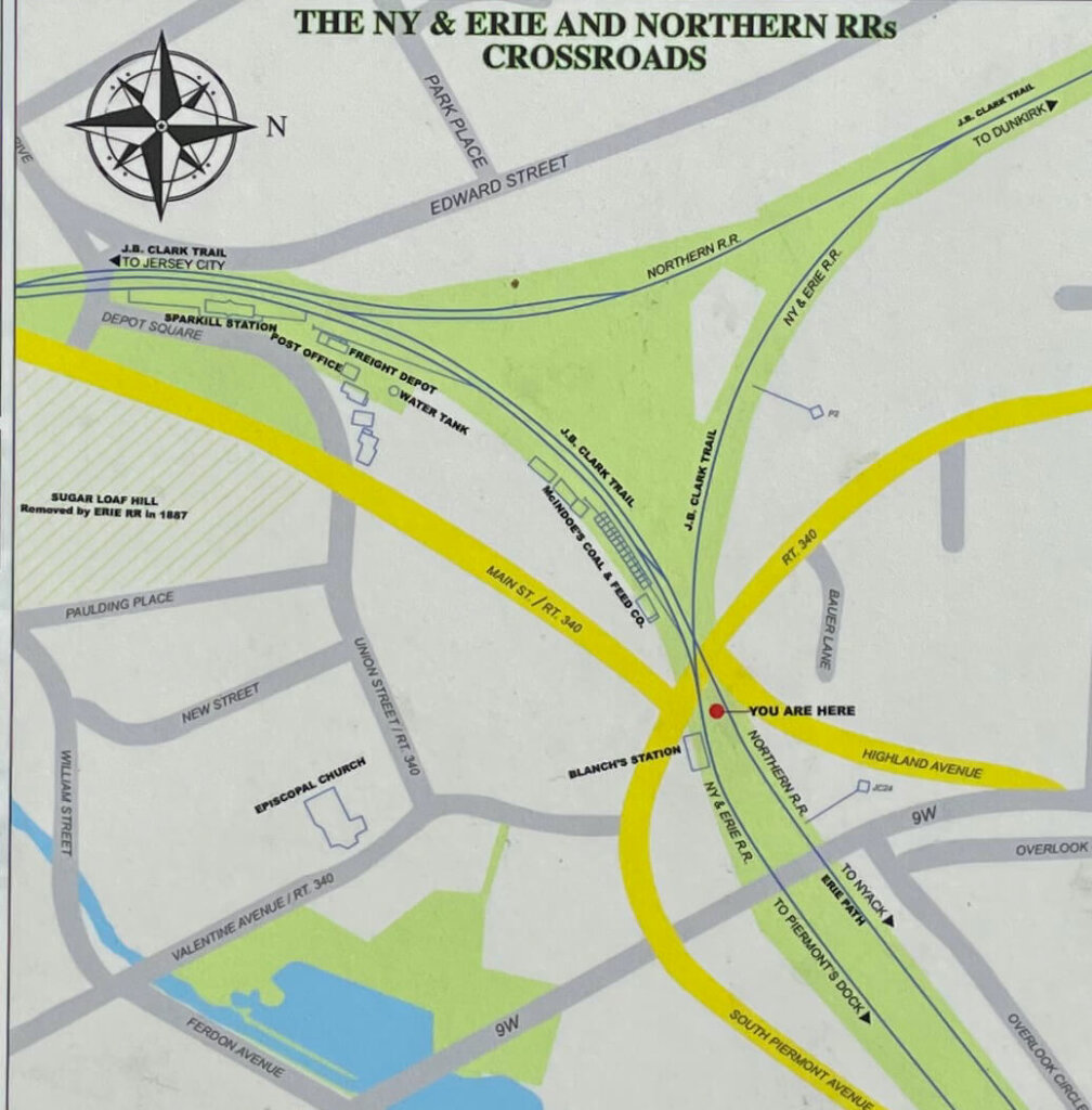
The map places Sugar Loaf near the old Sparkill station, helping confirm the hill’s location east of Depot Square.
A Landscape Built by Ice
To understand how Sugar Loaf formed, we have to go back thousands of years.
During the last Ice Age, a massive glacier covered the Hudson Valley. As it slowly retreated, streams of meltwater rushed along its edges, carrying sand, gravel, and rock. Over time, those materials piled into broad, flat-topped mounds.
Sugar Loaf was one of them.
▢ How a Glacier Built a Terrace
Sugar Loaf Hill was not carved from bedrock. It was built by ice.
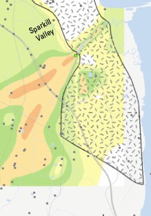
Alluvial deposits in the Sparkill valley. On this USGS map, the brown shaded areas indicate deep alluvial sand and gravel deposits, including deposits more than 100 feet high near the site of Sugar Loaf Hill.
Step 1 — Ice Advances
A massive glacier covers the Hudson Valley, grinding rock into sand, gravel, and debris.
Step 2 — Meltwater Flows
Streams rush along the glacier’s edge, carrying that loose material with them.
Step 3 — Deposits Build Up
Sand and gravel pile into layers against the ice, forming a broad, flat-topped mound.
Step 4 — Ice Disappears
When the glacier melts away, the mound remains as a steep-sided terrace.
Why it matters: Terraces look solid, but they are made of loose sand and gravel. That made Sugar Loaf easy to excavate and valuable to railroad builders who needed fill for Piermont Pier.
Geological maps confirm that similar deposits run throughout the Sparkill valley. One still stands today near the old rail line by Eastside Automotive. It rises higher than Sugar Loaf once did and shares the same distinctive shape.
That surviving terrace offers a useful comparison. It shows what Sugar Loaf likely looked like before the railroad stripped it away.
In the end, the geology and the history align. A hill formed by ice stood here for thousands of years. Then, in the space of a single year, it was gone.
What Replaced Sugar Loaf
Once the hill disappeared, development followed quickly.
Businesses rose on the newly leveled land. A hotel opened on or near the site and later became known as the Sugar Loaf Hotel and Café. The building still exists and preserves the name.
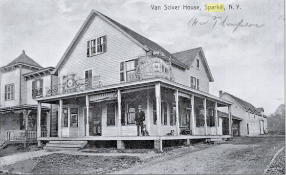
Nearby, the 1914 bank building anchors one end of the block. Its site reflects the subtle rise that once marked the hill’s footprint.
Mystery Solved
Taken together, the maps, photographs, geological evidence, and fieldwork by Perry and Mattsen tell the same story.
Sugar Loaf Hill stood in downtown Sparkill, just east of the train station. It rose roughly fifty feet, with a broad, flat summit shaded by trees. Formed by glacial forces, it survived into the railroad age until industry dismantled it for fill.
Its sand and gravel helped rebuild Piermont Pier. Its footprint became part of the modern village.
Today, little marks its presence. Yet the land still rises gently east of Depot Square before settling again. Beneath streets, buildings, and parking lots lies the footprint of a glacial hill that stood here for thousands of years before the railroad dismantled it for fill.
About the author
Mike Hays has lived in the Nyacks for 38 years. After a career as an executive at McGraw-Hill Education in New York City, he now focuses on researching, writing, and interpreting local history.
He serves as Treasurer and past President of the Historical Society of the Nyacks. He is also a Trustee of the Edward Hopper House Museum & Study Center and Historian for the Village of Upper Nyack. In these roles, he works with community partners to preserve historic resources and expand public understanding of the area’s past.
Since 2017, he has written the popular Nyack People & Places column for Nyack News & Views. The series chronicles the history, architecture, and personalities of the lower Hudson Valley.
Hays has also developed museum exhibitions, written interpretive materials, and led well-attended walking tours that bring Nyack’s history to life.
He is married to Bernie Richey. He enjoys cycling, history walks, and winters in Florida. You can follow him on Instagram at @UpperNyackMike
Editor’s note: This article is sponsored by Sun River Health and Ellis Sotheby’s International Realty. Sun River Health is a network of 43 Federally Qualified Health Centers (FQHCs) providing primary, dental, pediatric, OB-GYN, and behavioral health care to over 245,000 patients annually. Ellis Sotheby’s International Realty is the lower Hudson Valley’s Leader in Luxury. Located in the charming Hudson River village of Nyack, approximately 22 miles from New York City. Our agents are passionate about listing and selling extraordinary properties in the Lower Hudson Valley, including Rockland and Orange Counties, New York.