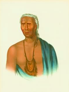
One of the first Native American portrait paintings is of Lappawinsoe, a southern Lenape who were related to the Munsees by language and custom.
Clausland Mountain. Sounds a bit like a commercial Santa-theme vacation park. What is it really? A relatively wild 1,000+ acre area spread over seven Orangetown villages. The Clausland Mountain area includes a state park, three county parks, and three town parks, several of which were only formed after struggles with landowners like Columbia University and developers. Its suburban wilderness encompasses a waterfall; an area once named Wolf’s Glen; the beginning of Sparkill Creek; a feeder to the Hackensack river; two cemeteries; views of Manhattan skyscrapers; a Cold War Nike missile base; a WWI training center named Camp Bluefields with graffiti-laden tunnels and target walls; a World War II lookout tower; Memorial Day Watchfires; a mountain biking path; numerous hiking paths, including the blue-blazed Long Path; Fat Man’s Agony; and the former site of Balance Rock, the largest glacier erratic in the lower Hudson Valley. Whew.
But which of the peaks between Nyack and Piermont is Clausland Mountain? And how was it named?
Clausland Mountain is topographically vague. The naming of the area and mountain, according to legend, refers to a seventeenth century Native American called Jan Claus whose Native American name was Tackamack. Claus’s story is an interesting one… but first, a quick survey of the
area and the Native Americans who lived here.
Clausland: The Palisades between Piermont and Nyack

Undated mid-19th century map showing a reference to the system of hills between Piermont and Nyack with the name “Clausland Mountain.”
Clausland is a name that was once used to refer to the area of hills on the Palisades ridgeline between Piermont and Nyack. It may have also referred to the settlements on the western slope and river valleys that now include Blauvelt and Orangeburg (Western Highway was once called Clausland Road). Clausland Mountain is a loose naming term. It may refer to one or all of the six Palisades hilltops between Piermont and Nyack. Old maps don’t agree which hill is which.
Early maps identify Mount Nebo, the tallest hill (at about 650 feet) and the southernmost elevation just above Piermont and the Rockland Cemetery. Mt. Nebo is one of seven such American versions of the eponymous biblical mountain in Jordan from which Moses viewed the Promised Land, and to the north, the River Jordan.
Just south of Nebo is Nike Overlook Park, and a second unnamed 630 ft. elevation with broad 500+ foot shoulders is most likely Clausland Mountain. Clausland Mountain Road, which is relatively old, divides Clausland from South Mountain with two hilltops, the first with Manhattan views in the distance and the second overlooking Nyack College, Nyack, and the Hudson River. On the western slope, an elevation called Snake Mountain rises above Buttermilk Falls with vistas looking out over the Hackensack River Valley and the Palisades Mall.
The Munsees, the Tappans and Ownership Deeds

Approximate sites of native American villages along the Hackensack River in Blauvelt, as mapped by John Scott using old maps and locations of artifacts. The sites are now mostly flooded by Lake Tappan.
Lower Hudson River Valley Native Americans are considered to be a part of the Munsees, the northernmost group of the Lenape, who were tied together by language and custom. The Tappans, a Munsee tribe, populated the area west of Clausland Mountain with villages centered along the Hackensack River in what is now West Nyack, Orangeburg, Blauvelt, and Tappan. Nyacks were Munsee migrants fleeing from what is now Coney Island
Speculators fueled a land rush in the late 1600s. The first step was to obtain a land patent from the government; second step was to find settlers; and last, to clear out the Native Americans. Deeds legalized the process. The Tappan Deed of 1681 transferred the northern Hackensack River valley to speculators. Six Native Americans signed the deed with their marks (Europeans also signed with marks). One signer was Jan Clase (sic), the only Native American with a western name.
Clues to Claus: What we know about Jan Claus
Who was the man who signed the Tappan deed? In fact, many mid- to late-seventeenth century deeds in the lower Hudson Valley were signed or witnessed by a person called Claus (with variable spelling). Were these the signatures of one person or several? Different historians add facts about Claus and, in some cases, judgments about the man.
- Peacemaker and Statesman. In the First Manhattans, Grumet identifies a man called Claes de Wilt, aka Claes the Indian, aka Towachkach (or Tackamack). He was a member of the Wiekuesecks, from what is now Westchester County. Claes the Indian was a translator and statesman who witnessed the second Bronx deed of 1685, signed at least four deeds in Westchester, signed or witnessed at least seven more deeds on the western side of the Hudson River, and attended high-level peace meetings including one in New Amsterdam that also included the Tappans.
- Con Man/Drunkard. Talman in How Things Began depicts Claus as a Wiekueseck who along with many of his tribesman lost his homeland during an early incursion by the northerly Mohawks. Having survived that raid, Claus goes on to sign a number of deeds starting in 1639. In Talman’s view, Claus was a “clever Indian,” there “with his hand out – or perhaps with his tongue out” trading land for drink.
- The Noble Savage. Budke in Indian Deeds declares Claus was a resident Tappan “brave” who was well known among white settlers, hence the given name, Jan Claus. He united with other Tappans and Hackensacks in selling the Tappan tract. Later, when De Hart purchased land north of the Tappan tract, Claus was one of the named “savages” who didn’t sign the conveyance. Budke suggests Claus’ nobility of character, at least as viewed by settlers, was the reason why the northern Hackensack River Valley was called Clausville and the mountain, Clausland.
- Chieftain. In The Munsees, Solomon identifies Claus as a chieftain of the “aborigines” while labeling other multiple deed signers like Assowaka of Tappan as fake “sachems.” Claus’ name was used as an authority in deeds whether he signed or not.
- Village leader. Win Perry, in an article on the LaRoue-Ackerman Patent of 1678, uncovers a new detail about Claus. This Patent conveyed the land from Nyack to Piermont, from shoreline to the top of the surrounding Hills. In the patent survey, one marker near Piermont is called “little Claes the Indian’s Plantation.”
Who was the real Claus?
A good argument might be made that Claus is a bit of all of the above. His adoption of a Western name indicates he was a culture broker between Native Americans and settlers. He spoke both languages and was present in many critical negotiations, although not as many perhaps as had been made out by some. His “tribal” origin is unknowable. In the upheaval of the times, movement from one place to another was the norm.
 Perhaps we are left to contemplate two things about Claus: a commanding presence who for a while lived on the Hudson River beneath mountains that later bore his name; and a trans-cultural individual who signed deeds with an eco-glyph of twin peaks. It is fit that we honor him in retaining the name, Clausland Mountain.
See also:
Sources:
George H. Budke, Indian Deeds 1630-1748, NY Public Library, 1975
Winston C. Perry Jr., The Laroe-Ackerman Patent of 1678, South of the Mountains Vol. 4, 1997
Wilfred Blanch Talman, How Things Began in Rockland County and Places Nearby, The Historical Society of Rockland County, 1977
John Harris Salomon, Indians of the Lower Hudson Region: The Munsee, Historical Society of Rockland, 1982
Robert S. Grumet, First Manhattans, A History of the Indians of Greater New York, University of Oklahoma Press, 2011
Michael Hays is a 30-year resident of the Nyacks. He grew up the son of a professor and nurse in Champaign, Illinois. He has recently retired from a long career in educational publishing with Prentice-Hall and McGraw-Hill. He is an avid cyclist, amateur historian and photographer, gardener, and dog walker. He has enjoyed more years than he cares to count with his beautiful companion, Bernie Richey. You can follow him on Instagram as UpperNyackMike.

 Nyack People & Places, a weekly series that features photos and profiles of citizens and scenes near Nyack, NY, is brought to you by HRHCare and Weld Realty.