by Max Cea
A quick Rorschach Test for you: What do you see in this image?

This image?

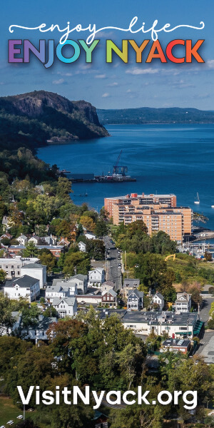
If you answered “Nyack,” you’re not alone. (If you answered “My mother,” uhhh… .) In a March survey of Nyack residents (South Nyack and Upper Nyack included), 44% of over 900 respondents said that the Hudson River is the symbol that best represents Nyack. That was the plurality answer, ahead of Main Street (34%), the Tappan Zee Bridge (15%), Edward Hopper (6%), and measly Hook Mountain (0%). The Hudson River waterfront, too, was the most frequent response to “What do you think are Nyack’s greatest assets?” – 83% of 937 respondents chose it (respondents were able to choose as many assets as they liked on that question).
And so, Wednesday’s Comprehensive Master Plan meeting, the fifth of seven, was arguably the most important. The topic at hand: Waterfront Development and Ferry Potential.
Which may not sound sexy, but you’d have thought the Nyack Center was hosting the ghost of Whispering Jack Smith; it was a packed house, filled mostly with people who could sing you a few Whispering Jack Smith songs, and who again and again shouted at the BFJ Planning presenters, “We can’t hear you!” and “Louder!” (It wasn’t as though the presenters were whispering.)
For those who couldn’t hear, or didn’t attend, here’s what went down:
The first major question at hand was one raised rhetorically by Perkins Eastman consultant Eric Fang: “How can we preserve and maintain the way of life that we all enjoy here while expanding economic activity to the waterfront? How can that be done in such a way that it increases access to the waterfront, makes it a better place for residents, and also a better place to visit?”
Specific proposals have not been drafted. But several intriguing concepts were presented. These included re-envisioning Memorial Park, Clermont Park or the Nyack Boat Club as a waterfront destination, perhaps with a performance space or art installation; building a continuous riverfront path from the Nyack Boat Club through Memorial Park; and building a marina parcel where a ferry could dock.
About that ferry. Nyack might get a ferry! Where? When? How often will it travel? — these questions remain up in the air. The presenters did make one thing clear though: If Nyack does get a ferry it won’t be Staten Island Ferry size. We’re looking more at a small to midsize vessel. Imagine a water taxi.
Three proposals were discussed at the meeting:
- Option 1: A seasonal recreation and tourism ferry that would either travel between Nyack and other Hudson River villages or between Nyack and New York City. This option would require a parking terrace with 85 spaces.
- Option 2: A commuter ferry that would provide direct access to the Metro-North Railroad; it would be comparable to the ferries that run from Newburgh to Beacon and Haverstraw to Ossining. This option would require a parking terrace with 280 to 220 spaces.
- Option 3: A commuter ferry that would travel between Nyack and lower Manhattan in approximately 65 minutes. This ferry would be an alternative to automobile and bus, and would be comparable to the Highlands, NJ to Wall Street Ferry operations. Though this option may sound most enticing for Nyack residents, in order for it to be economical the Metro North would likely have to subsidize it. While that seems unlikely, Nyack is growing and is currently home to more than 1800 Manhattan commuters, the majority (57%) of whom have household incomes greater than $150,000. So, even if Option 3 is not the immediate choice, it’s conceivable that a commuter ferry could dock in a Nyack harbor years from now. This option would require a parking terrace with 280 to 220 spaces.
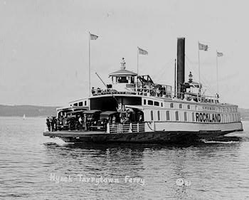
1921 photo of “The Rockland,” a ferry, on river between Nyack and Tarrytown, New York.
Photo Credit: Library of Congress
A group discussion session followed the presentation. Data on residents’ preferences for the waterfront should be available in the coming weeks. Though the plans for the waterfront and a potential ferry are all exciting, they could be costly. The BFJ team acknowledged villagers’ fiscal concerns. “One of the key areas that survey respondents wanted to change was ‘high taxes,'” BFJ Susan Favate said. “That tells us that we need to be economically responsible.”
The penultimate CMP meeting, on economic development, will take place on April 20th.