by Mike Hays
Nyack’s first brewery, first cemetery, a school, its first east-west road, and a site with a Native American ghost legend were once located along what is today an unnoticed mile-long brook. The Upper Nyack Brook begins in a spring near the current Nyack High School and runs directly down to the Hudson River. An old Native American trail follows the brook from the top of the notch between Garabrant Hill and Hook Mountain, down to the river. European settlers built a road on the trail, calling it the “Road to the Pond,” which branched off from the “Road to the Hook” (what today is Broadway). It was the only way west from Nyack before the Nyack Turnpike was built in 1825. The road is now called Christian Herald–until it crosses Midland Avenue, where it becomes Old Mountain Road–and is driven on by thousands of people who give little or no thought to its historic status.
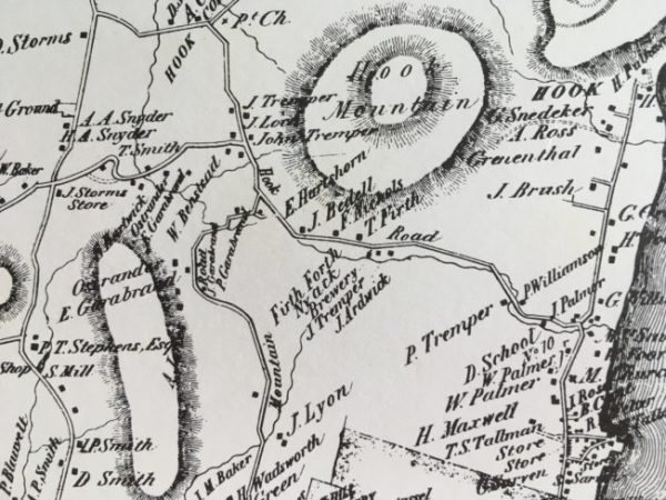
An 1854 map of Upper Nyack. The road on the right parallel to the river is N. Broadway. You can see the brook running along what is labeled the Hook Road (now Old Mountain and Christian Herald). The location of the school and Brewery are labeled along this road that ends in what is now Valley Cottage.
The Brewery
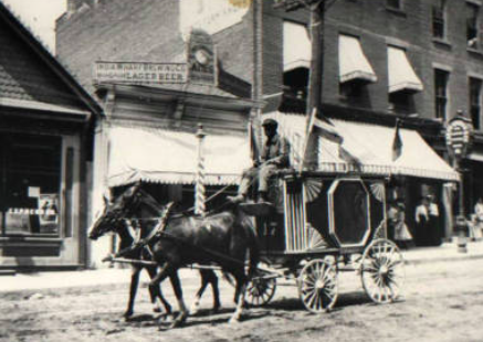
Breweries have been in Nyack for a long time. This 1900 photo shows the India Wharf Brewery in downtown Nyack (where the Hudson Mercantile is now located.)
The Firth Forth Nyack Brewery appears on an 1854 Rockland County map near the brook’s source, likely a spring-fed pond. The Firth of Forth is a well-known estuary in Scotland. The brewer, one assumes, was a person identified on the 1854 map as T. Forth who lived just across Christian Herald Road; hence, the brewery name. The brewery site is commemorated today by an organic garden run by Thomas Perry, a Nyack High School teacher.
Spook Hollow and the Legend of Camboan
A small spring-fed hollow with a dammed up pond once known as “Spook Hollow” is hidden just off of the intersection of 9-W and Christian Herald. The pond was once a swamp, and it has an outlet stream, now piped, to the Upper Nyack Brook. The nearby streets of Camboan and Spook Hollow memorialize the legend of the last Native American to live in Nyack, a man named Camboan.
Around 1670, as the story goes, Camboan’s tribe left the Nyack area. He remained, camping within the glen at Spook Hollow. Camboan reportedly befriended the Dutch settlers. Legend has it that he tracked down two young girls who had been lost for five days in the woods. At some point, Camboan disappeared and was not seen again. However, rumors of moccasin prints and campfire smoke in the glen persist after his disappearance. In time, the rumors led to the idea that his ghost (or “spook” in Dutch) inhabited the area.
Camboan’s ghost has been rumored to appear near Hook Mountain in late September near the equinox. Camboan’s legend undoubtedly became immortalized as the Indian ghost seen in Anderson’s 1936 Pulitzer Prize winning play, High Tor.
Upper Nyack’s First School
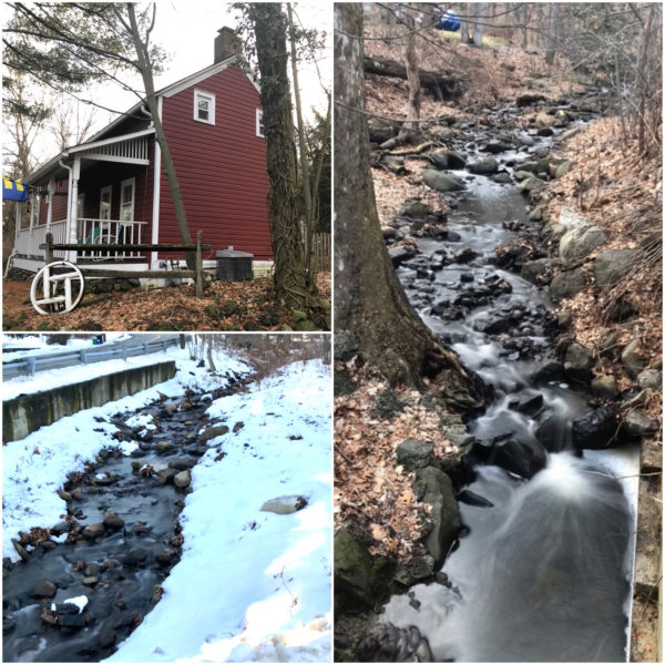
The Tremper house today and photos of the nearby brook.
Christian Herald Road becomes Old Mountain Road in an awkward junction as it crosses Midland Avenue. At the southwest corner of the junction stands the P. Tremper house, a red-painted country house on a tiny lot that was carved out of a large farm in 1834. It is one of the few wooden homes from the early 19th century left in Nyack that has retained its early form.
Just downstream from the Tremper House, where an arts-and-craft style home now stands, was the first Upper Nyack schoolhouse. It was a small one-room wood building measuring 18 x 26 feet and costing $263.82. A few years later, a porch and privy were added. At first, it was a private school and teachers were paid $28 per year. By 1884, the school was moved to a lot at the end of School Street.
Old Palmer Burial Grounds
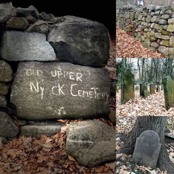 On the north side of Old Mountain Road, across a deep ravine carved out by the brook, is the Old Palmer Burial Grounds. It is one of the two oldest burial grounds in Clarkstown; it may contain over 80 burials. Fifty gravestones have been identified; the oldest is labeled C.K.D., referring to Corneilius Kuyper, who died on May 5, 1731. Kuyper owned all of the land from Hook Mountain to South Nyack but for a small tract owned by Dowe Tallman. At least three revolutionary war soldiers and at least 18 children under the age of three are buried there. A slave cemetery now lost to time was also located upstream nearer the brook. Almost 100 years after Kuyper died, James Palmer deeded the burial grounds to 24 trustees.
Crumbie’s Glen
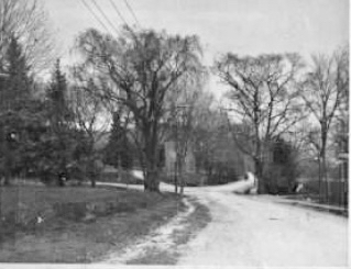
An early photo looking north down Broadway. the road on the left is Old Mountain. The road in the center leads to the Green house which at the time can be seen located closer to the road before it was moved back. (Courtesy the Nyack Library.)
Upper Nyack Brook widens into Crumbie’s Glen as it crosses Broadway at the intersection with Old Mountain Road. These were once the only roads leading to Upper Nyack farms. On commanding hills on each side of the intersection are two picaresque old homes.
On the Northwest corner is a three-country style house. Once situated close to the intersection, it was moved to its current site and expanded around 1900. Garret Green, a grandson of John Green once lived there and may have built the original house. (John Green was a businessman whose house on lower Main Street is Nyack’s last remaining early stone house.)
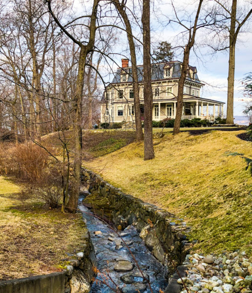
The Crumbie House today viewed from Broadway. The house overlooks the Hudson River. The brook curves around the house before falling swiftly downhill to the river.
On the other side of Broadway, also on a small hill, is the Victorian home referred to as “Glenholme.” It was built by Frank Crumbie, the mayor of Upper Nyack from 1912 to 1937. Movie stars have traipsed through Glenholme in recent years. It was the family home in the 1998 Julia Roberts and Susan Sarandon movie, Stepmom; it also was used in the 2010 Jennifer Aniston-Gerard Butler rom-com, The Bounty Hunter.
The brook flows around the house and then downhill from Cumbie’s Glen to the Hudson River. Rainstorms create cascading waterfalls that are hidden from public view as a gated private road cuts off access. Near here, Native Americans who followed the path along the brook would camp in summer where the brook enters the Hudson River, a perfect spot for fishing and oystering.
Photo Credits: Photos by Mike Hays. The 1854 map photo is courtesy of Thomas Perry. The Black-and-White photo of Broadway is provided Courtesy of the Nyack Library.
Acknowledgement is made to Win Perry for reading an early draft of this article.
Michael Hays is a 30-year resident of the Nyacks. He grew up the son of a professor and nurse in Champaign, Illinois. He has recently retired from a long career in educational publishing with Prentice-Hall and McGraw-Hill. He is an avid cyclist, amateur historian and photographer, gardener, and dog walker. He has enjoyed more years than he cares to count with his beautiful companion, Bernie Richey. You can follow him on Instagram as UpperNyackMike.

 Nyack People & Places, a weekly series that features photos and profiles of citizens and scenes near Nyack, NY, is brought to you by HRHCare and Weld Realty.